
We were searching for a mountain that is within Metro Manila and would only take a few hours of travel. Our search brought us to the Mt. Balagbag of Rodriguez, Rizal. Upon hearing from other hikers that you could traverse from Balagbag to Maranat and enjoy the falls there, we decided to revise the itinerary. After finalizing everything, our group of eight set off to satisfy our wanderlust.
We
gathered in Tungko Jollibee at 4:30AM. We wanted to catch the sea of clouds in
Balagbag at the early hour of the dawn. Unfortunately, when we went to the
terminal of jeep bound to Licao-Licao, the transport was not yet available. The
first jeep arrived at 5:30AM and waited for passengers to fill in all the
seats. SO we started heading to Licao-Licao at already 6:30AM! Sea of clouds
became a hopeless thing.
Anyway,
there were still so many beautiful things to look forward to. When we arrived
in Licao-Licao terminal at 7:30AM, we walked for about half an hour before
reaching the barangay office of Sitio Balagbag in Brgy. San Isidro. We
registered our name and hired a guide for Balagbag-Maranat traverse.
In
able to traverse Maranat you have to sign an agreement form that you and
your group will strictly comply with the rules and regulations written in the
copy. From the recent months, the locals of Maranat found cigarette butts and
other discarded piece of waste in the Maranat River. It is sad to know that
such unacceptable practices were committed by our fellow mountaineers. The
river is linked to the dam that supplies the water for the entire households of Metro
Manila. Whether we are the end-user of that water or not, we should be concern
and responsible for the environment.
ALWAYS
LNT (Leave No Trace)
About Balagbag
Mt.
Balagbag is a favourite place of many hikers because of its proximity to the
metro. The only main difficulty in hiking this mountain is when it rains and
the trail becomes muddy. The trail is wide with its dark-brown soils. Balagbag used to be covered with trees. Now, a big portion of the mountain was already
barren. There are growing numbers now of community that cover more
space for the residents to build in their houses.


In
the last community we passed through, we met a friendly mountain dog named
Haidee. She accompanied us all the way to the top of Balagbag, to Maranat and
back. On the spacious dry trail, you could see the metro from afar. I couldn’t
tell if the murky clouds from that end were due to the impending rain or to the
pollution that has been clouding the city.
We didn't realize that we were already few minutes away from the topmost part of
Balagbag. It was a short climb from the jump-off. The trail was a bit
exhaustive because of the semi slope formation of the land. It will become more
exhaustive on the summer days because of the too much exposure in the sun, since
there are no trees to cover the hikers.

Before
you can proceed to the peak of Balagbag you need to pass another station
and register. It was actually the station for registering and paying the fee for the Maranat traverse. The man stationed there asked if we have permit
to trek Maranat. The only paper we had was the agreement form that we were
asked to sign from the barangay of Balagbag. I wasn’t sure if he meant the
other document but he let us passed anyway. I think there was no clear
coordination between the local government councils of Maranat and Balagbag
regarding the regulations of hiking activities in the two mountains (Let’s
discuss it further later.)

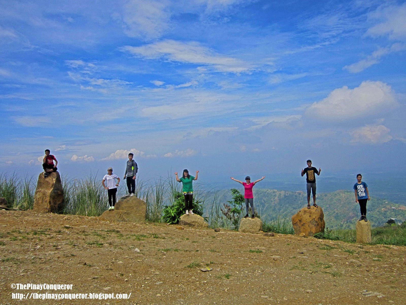
We were the only people in the peak. It was quiet and gloomy because of the darkening sky. But it was a nice place to camp. It is surely cozy and more beautiful there during the sunny season.


Pictures
and selfies were taken with our newfound friends, Haidee the dog and Garfield
the cat.


GOING to MARANAT FALLS


Maranat
trails offered a challenging experience of up and down slopes and breathtaking
scenery of rolling terrains and rich greenery. The trek was more difficult
but gratifying. In each assault you would be greeted by awesome views.
Everywhere you look at was worthy of praise. There were also Haidee and Garfield tagging
along. We tried to send Garfield back because it would be a long walk for a cat
but he kept on following.


For
the entire trek I couldn’t help stopping by and taking pictures of the
surrounding. It was all green and mountains and grasses everywhere but you
could tell one view from the other – each has distinct forms and looks, and all
were precious and beautiful to look at.


It
was a long walk and it started to drizzle again. We asked if we were already
near but our guide gave nothing but a smile for an answer. It took us almost
two hours to reach the river. If you were looking for an exercise go ahead to
Maranat. You will have a full of it.

Our
hopes lighten up when we finally heard the sound of flowing waters. But it
was still a long trek along the rocky and slippery slopes. My feet were already
tired but we needed to keep going. Haidee was still with us but Garfield was
nowhere to be seen. He’d probably gone the other way.


And
finally we reached the Maranat River! We rested on the huge rocks while
enjoying the views of the green water and eating our remaining foods. Frugal
meal it was but we just vowed to eat like a horse down to the jump-off. There was a hose there where water from a spring source came from.
You can drink this fresh and cold water. So of course we never wasted the time
but plunge right away to the river. It was cold, but soothing the soreness we
felt in the trek. Haidee was just up there in the rocks as we played
like kids in the water.


Just
after half an hour of playing and bathing in the river, it rained for real.
Yes, as in for real. We were not
prepared for this, good thing we have some plastics to keep our gadgets from soaking. We
tried to wait for the rain to stop but it just got stronger and harsher. We
couldn’t stay long enough because we needed to catch the last trip of jeep in
Licao Licao that was only until 6PM. We prayed for guidance and braved the
rain.


We
took the other way in getting back to the jump-off. The trail got more slippery
and dangerous than it did a while ago. Thank goodness the rain had stopped when
we reached the middle. But still, the muddy soil made our pace slower. Despite
the harsh weather there was a good thing that occurred after. We saw a bit sea
of clouds along the way. I felt like singing “there’s a sea of clouds (instead
of rainbow) after the rain” hehe. I wasn’t lucky enough in my past hikes to witness
a sea of clouds. So this one really made me like a happy kid who was given with
cotton candy.


We
passed through some small streams and washed our muddy sandals and shoes. There were huts nearby these streams. A group of men called our
attention. They asked if we have permit in trekking to Maranat. It seemed that
they were an environmental group (or under DENR, I wasn’t sure) who were
working on projects related to Maranat. They explained why the local government
unit has restricted the hikers from exploring Maranat. There were some irresponsible
hikers who just keep on leaving their wastes in the area. If the local units didn’t
make an action the river will be polluted and all of the people in the metro
will suffer from its effect. We assured them that we didn't leave anything back
in the river and that we carried our garbage with us. They told us that Maranat is
supposed to be closed from hikers for the mean time – I think it was sort of
saying that we were supposed to be not there in the first place. It confused me
because if that was the case, why then the locals from the jump off let us
passed? Hope they can clarify and officially announce to everyone if Maranat
was really close for hiking. And hope both the local units of Balagbag and Maranat can have a clear coordination.


We proceeded on our way and passed through a store that offered pansit and coffee. Of course we gave Haidee a plate of pansit too. We ate quick and walked fast enough to catch the last trip of the jeep. It was almost 6:30PM but lucky us, the last jeep was still waiting for passengers. We only took a quick bath and changed to dry clothes. We never see Haidee in the jeep terminal. She had probably gone back to his family’s house.


We proceeded on our way and passed through a store that offered pansit and coffee. Of course we gave Haidee a plate of pansit too. We ate quick and walked fast enough to catch the last trip of the jeep. It was almost 6:30PM but lucky us, the last jeep was still waiting for passengers. We only took a quick bath and changed to dry clothes. We never see Haidee in the jeep terminal. She had probably gone back to his family’s house.
It
was a longggg day for us but definitely a worthy one!


